Updated July 14, 2014
This is a short cut to an old lookout just off of Hwy 410 and just east of the town of Greenwater. This is a part road walk and part trail hike with great views in all directions and wildflowers are prime. Thanks to Dennis Long for photos and track
 |
| Beargrass and Mt. Rainer @ Dennis Long |
 |
| Beargrass and Michael @ Dennis Long |
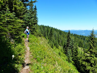 |
| Looking east towards Mt. Stuart @ Dennis Long |
 |
| Tiger Lilly and more flowers @ Dennis Long | | |
Directions: Take Highway 410 east and past the town of Greenwater turn left on FS 7000 and less than mile and turn left on FS 7010 and follow several miles and left on NFD 110 to trail. Please see map below and bring your own map as well. You will drive about 7 miles on the logging roads before you get to the trailhead.
Stats: Only 6.2 miles roundtip with the ups and downs elevation gain of about 1000 feet
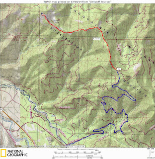 |
Map of road and trail
Disclaimer: There are many factors which you should consider in
deciding whether to proceed with an outing, including the visible
weather at the trailhead, the strength and experience of the party, snow
and avalanche conditions, route conditions, etc. You are the final
decision maker whether to proceed. West Coast Weather, LLC dba
Washington Online Weather cannot be held liable for loss or injury
arising from your decision to proceed, and expressly disclaims all
liability related thereto.
Redmond, Washington USA. Also, please bring map-compass and GPS to help
with trail directions as our directions are our best estimate.
Custom Weather Forecasts Services
 |
| Click to check out our forensic & custom weather services |
Email us West Coast Weather Contact us |


No comments:
Post a Comment